It's All Downhill From Here On Up
By McKenzie Funk
First published in National Geographic Adventure, August 2004
Objectively speaking, being lost in a wilderness of shirt-tearing, skin-scratching, path-obscuring ten-foot-tall rhododendron bushes is pretty miserable. And two hours after we lost the trail, wandered into the thicket, and started crawling over all those logs—just before the wasps stung Lisa six times—Jim even went so far as to admit it. "You know," he said, "this is pretty miserable." His tone suggested he was merely noting an established truth about hiking in rhododendrons—personally, he wasn't all that flustered. But he did say something, and for that we were grateful. We kept moving.
At eighty-one years old, Jim Harrang walks just like he walked at seventy-one and probably fifty-one and probably twenty-one: deliberately and relentlessly, taking long strides on long legs, silent except for periodic bursts of good cheer. ("Say, this could be the world's longest bushwhack." "These rhodies are a good reference point—after this, most anything's gonna seem easy." "Well, Mac, there's always next weekend.") Soft-spoken and pathologically optimistic, he’s the subject of a cult of personality in our hometown of Eugene, Oregon. Get to know him or know of him, and you realize all his adventures follow a basic pattern: First, he leads a group of people half his age on what is promised to be an “interesting” trip. “Interesting” is Jim’s word for “grueling.” Next, they run into adversity, perhaps in the form of rainstorms or blizzards or ten-mile uphills. But Jim doesn’t acknowledge any of it as a hardship, and they slog on for hours and hours and hours.
Jim had been his typical hopeful self when he proposed our hike a few weeks earlier. He and his wife Nadine had strolled across the field that separates my parents’ house from theirs. Nadine brought a homemade cobbler, Jim a half-baked plan. "We've got some serious business to discuss," he said when he arrived. Over dinner, he described the Oregon equivalent of a buried treasure: a forgotten trail, unmaintained since World War II, that climbed into the wild heart of the Cascade Range. The trail didn't appear on modern maps, he said, and he was one of the few people alive who knew of its existence. He spoke of waterfalls, meadows, and old growth. He promised we would pass through four distinct bio-zones. He described blazes, left on trees by long-dead Forest Service workers, that would help us find our way. When the Harrang kids were kids—they’re now in their forties and fifties—this was the family’s secret route. Jim had decided it was time to show it to another generation.
He failed to mention that the last time he'd hiked the trail was in 1987, but that, no doubt, hardly seemed relevant at the time.
When I was growing up, Jim’s role in my life fell somewhere between guru and grandfather. He drew my parents into his orbit soon after they bought the farmhouse next door in 1976, the same year I was born, and I was raised not only with Jim stories but in the presence of the man himself. It was Jim who introduced my parents to what would become the family passion, river rafting. Some of my earliest outdoor memories—cross-country skiing at Santiam Pass, floating the McKenzie River, my namesake—include a hazy recollection of someone my dad referred to as “old one-stroke.” It was a nickname for Jim, whose raft was always so perfectly aligned in rapids that he seemed to glide through with a single stroke of the oars.
Once, on a trip down the Middle Fork of Idaho’s Salmon River, my parents, sister, and I watched from camp as Jim, then in his sixties, bouldered on a rock above the water. He fell in, lost his eyeglasses, and had to run the next four days of river half-blind. This, my parents explained, was inspiring.
Until they moved on to my more dependable sister, the Harrangs called on me to watch their house and feed their dogs when they were away. It was like sitting in port, watching the ships come and go. They rode off with bikes or boats or hiking gear, returning days or weeks later. The destination might be the three highest peaks in Africa, or maybe Alaska, which required rafts but also rifles, in case of a bear attack. Or just somewhere in Oregon. In down periods, Nadine worked in her garden while Jim was in his gear shed, saddling up, or downtown at his office. (He heads one of the state’s top law firms.)
Jim never gave me advice, but every now and then he’d give or lend me a book: an American Alpine Journal chronicling the year’s boldest mountaineering ascents, for instance, or the biography of famous Oregon outdoorsman Prince Helfrich, who’d spent a lifetime exploring the Cascades. By example, Jim showed that going out into nature was a completely normal thing to do—even a necessity. “A night indoors is a night wasted,” he told me. He had structured his existence around the idea that the outdoors weren’t an escape from real life but the basis for it.
But Jim’s support was as much logistical as it was spiritual. My first self-led mountaineering trip, a spring climb with two classmates up 8,744-foot Diamond Peak, was only possible thanks to Harrang gear. His ancient crampons and unwieldy glacier axes featured heavily in our photos; his orange climbing rope, which we never needed, made us feel tough. I began asking to borrow equipment so often that he instituted an open-lending policy at the gear shed. I liked to walk over late at night after last-minute planning sessions with friends, using my headlamp only once I’d entered the shed to avoid waking anyone up.
The furtive trip became second nature: slip behind barn, step over blackberry bushes, undo wire securing gate, tiptoe through the Harrang yard, open shed door at a snail’s pace lest its squeak set off the dogs. The rope, crampons, and axes were hanging to the right, just inside the door; paddles were knee-high, lying flat with the oars; the inflatable kayak was in another room altogether, along with the two big rafts.
The essay I wrote to get into college was an ode to my then-seventy-year-old neighbor. “In the house next to mine,” it began, “a few hundred yards off, lives one of the people I admire most. His name is Jim Harrang and he has the distinction (along with his wife, Nadine) of being one of the few neighbors I truly like. The fact that Jim didn’t cut down the forest I grew up in, or doesn’t practice with his band until three am, like other neighbors, is not reason enough to respect the man as much as I do. I respect Jim because he is living the life I hope to live in the future.”
When I ended up wanting to defer college for a year, winter in the Tetons, and earn money for a spring trip to Europe and its Alps, my mom tried to enlist Jim in her all-out war to keep me on track. To her dismay, he was one of my only adult allies. “That sounds great,” he said. I took the year off.
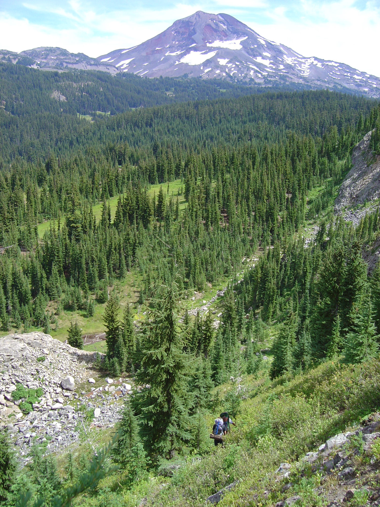
About sixty miles east of Eugene, the old McKenzie Highway branches off the new McKenzie Highway and starts winding up into the Cascades. These days, people drive it less to reach civilization on the other end than to see the wilderness areas—Mount Washington and the Three Sisters—that lie on either side. There are lava flows and glaciers, black bears and brown trout, huckleberries and stands of Douglas fir. My parents, who briefly lived in these parts before moving next to the Harrangs, like to joke that I was named after these thirty-seven miles of two-lane road. Thanks to climbing trips and fishing trips, I saw a lot of the old highway growing up, and it was odd to think that Jim’s secret trail lurked on such familiar ground. Yet that's where he steered his minivan when it came time to sniff it out.
It was late October and the days were already colder, shorter. We camped just off the highway, then got an early start, hiking due south from a parking lot, a cement outhouse, and a sign that had welcomed us to the Willamette National Forest. Within minutes, Jim had us on track. The trail started out as a spur off of the popular Proxy Falls loop—drive-by tourists’ favorite mile-long hike—and at first it was a veritable autobahn. But after fifteen feet the space narrowed and nearly disappeared. Our five-person hiking party kept going, clambering over a downed tree and following the faint path into a fern-filled ravine. The forest darkened, a headwall rose above us, and suddenly there it was: a blaze, the first of hundreds, seared into the trunk of a trailside fir. Jim had told us what to expect, of course, but nevertheless I felt a strange rush of discovery. The trail was underfoot. The blazes were real. Even as the forest crept to reclaim it, the treasure was right here, just yards away from discovery by the rest of the world.
Early on, we learned to distinguish blazes from natural scars: If there was only one—not a matching mark on the other side—it was probably just a scar. We peered at tree trunk after tree trunk whenever we got off course, quietly fanning out in a dragnet until someone yelled, "Hey, I've got one." Also early on, Jim began assuring us that the hike was going well. When we crested the first pitch and came to a narrow granitic fin, jutting from the earth, he advised me to "fix this in your mind, Mac." It was an ideal landmark. When we spotted a forty-foot plume of water that cascaded onto the mossy rocks below, he declared confidently, "Now that might be the waterfall." We hadn't known we were looking for one. When we hit a streak of obvious blazes a half hour later, he sounded a triumphant note: "I think we're on it," he said. "Here's another one." Then, "Yeah, there's one here." Then he yodeled, calmly. Then, "I think this is it, Mac." When the streak ended below a broad lava field fringed by yellow and orange vine maples, he was more pensive. "This is kind of like life itself," he reminded us. "The future is uncertain."
At camp the previous night, I’d stayed up late with two of Jim’s latest young co-conspirators, Lisa and John Manotti, poking fun at his inability to say anything negative. I shared my dad’s story of a Christmastime cross-country ski trip with Jim and family. Deep, heavy snow had hidden the trail to the Cascades’ Burley Lakes, and they started to get off course, inadvertently climbing the steep flanks of an 8,000-foot volcano. When the clouds cleared and they realized their mistake, they headed back, my dad falling over and over again. Frustrated and exhausted after the twentieth face plant, he was again struggling back to his feet when Jim said, “Golly, Dave. You sure are good at getting up from falls. That’s quite a talent.”
More recently, in the canyons of Utah’s Escalante, Jim was spotted dipping his hiking boots nonchalantly in a water pocket. Someone asked what he was doing. “Well, I think I might be having a little bit of a toe problem here.” Two toenails had turned completely black; to even brush them must have been enormously painful. They cut the big toes out of some running shoes, and he donned them and a full backpack and hiked out twelve miles the next day.
Lisa and John told me about their first Cascades climb with Jim, a successful ascent of Mount Washington, when his insistence that they park at an obsolete trailhead condemned them to a post-sunset bushwhack back to the car. (Followers soon learn to carry headlamps at all times.) When they finally got back, Jim's only comment was this: "Well, that certainly was a full day, now wasn't it?" The Manottis still employ that phrase all the time, just as my parents and I say "interesting" when describing hell. We’ve taken to repeating an apparent Harrang family motto, which Jim's kids must have come up with during a walk with Dad: "It's all downhill from here on up."
Somewhere in all this, it seemed, was a blueprint for how to commune with nature: Be bullheaded. Never let the fact that you’re having a horrible time of things get in the way of the good times. The wonder of your surroundings always outshines the specifics of your difficulties. Never admit that you’re cold, lost, hungry, or hurt. Never admit that you’re discouraged. Never admit that something sucks. Ignore adversity. It’ll go away. Hardship, it turns out, is the spice. With sufficient underplanning and a good dash of stubbornness, a jaunt in the Cascades can be every bit as life-changing as a Himalayan expedition.
As far as Jim has ever gone—the Andes, the Alps, the Caucasus—he has always seemed most content in the state where he was born, exploring the mountains where he grew up. After his tour with the Army’s 10th Mountain Division in World War II, he returned to found the University of Oregon’s ski team with some Army friends and some Army skis. (They competed in all four disciplines—downhill, slalom, cross-country, and jumping—on the same seven-foot, government-issue wooden planks.) In the 1940’s and '50’s, with a cadre of climbers that included Willi Unsoeld, who went on famously to conquer Everest's West Ridge, Jim pulled off a number of first ascents in the Cascades—but he never joined them in the high Himalaya. For his eightieth birthday, he summitted the tallest mountain in Oregon, 11,239-foot Mount Hood.
His connection to the home state rubbed off on me. During summer breaks from college, when many of my friends stuck around the East Coast for this or that impressive internship, I made a beeline back to Oregon and worked as a rafting guide. The first time I ran a river with my boss, Jim happened to be along. She watched in silence as I botched the run down Pinball, the trickiest Class IV rapid on the Umpqua River, missing the entrance chute and getting sucked all the way to the right. I bounced sideways over rocks and holes just inches from the bank. But Jim knew just what to say. “Wow, Mac, I hadn’t even noticed that slip route. What a great idea to save yourself all that maneuvering.”
Even now, after living in Jackson Hole, Philadelphia, Washington, D.C., New York, Seattle, and again New York, I’ve clung obsessively (and probably illegally) onto tokens of Oregon identity: driver’s license, vehicle plates, mailing address for anything important. I still spend at least a month there each year. Any opportunity to go home, I take, and the visits invariably revolve around some epic ski, trek, climb, or paddle in the Cascades.
Jim had neglected to bring a topo map on our hike. So had I. It didn't matter much, he'd reasoned—the trail wasn't shown on it anyway. Thankfully, that wayward disciple John Manotti had been overly cautious, and it was his map that we all huddled over once we were good and lost in the rhododendron thicket. The topo showed lots of valleys and creeks and ridges, and I think we followed one of those ridges for quite a while. The rhodies made it hard to tell. We wandered for two hours, maybe three. Lisa informed Jim that she was ready for another bio-zone. We ate a snack. But the trail never reappeared, and eventually John's map—and the swarm of wasps that beset Lisa as we descended a brushy hillside—persuaded us to turn around.
By the time we hit the car, Jim was calling our hike an "exploratory mission." By the middle of the next week, he'd dismissed the wasps as "kind of a fluke." Meanwhile, Nadine had instructed Lisa on how to make a meat-tenderizer poultice to reduce the swelling from her stings (somehow, Nadine had had occasion to master this remedy), and I had become obsessed. I spent my days poring over historical maps in the University of Oregon library. My studiousness, though certainly not my stubbornness, may have been a break from Harrang tradition; I lack his ability to make things look effortless. But the real hike, not the mere exploratory mission, was planned for the coming weekend, and this time I wanted to be fully prepared.
The oldest Three Sisters map I dug up, a topo drawn in 1925 by a geologist named Edwin T. Hodge, didn't show Jim's trail. Nor did any subsequent USGS quadrangle, from the first one, made in 1932, to the current one, printed in 1997. On the 1930 Forest Service map of what was then called the Cascade National Forest, however, a weak dotted line climbed up the headwall next to Proxy Falls, switchbacking its way to the base of the Sisters. In 1940 the line was stronger and more obvious. In 1967 it was even drawn in red. After that, though, it vanished. The maps all showed the same important detail: Not far past the lava field, where we'd gone straight uphill and found rhododendrons, the trail cut left and forded Proxy Creek. We'd missed the crossing, simple as that.
The paper trail intrigued me. Why had it been mapped and official for only thirty-seven years? Had the Forest Service simply lacked the resources to maintain it, as Jim supposed? My calls to the McKenzie Ranger Station finally led me to Jim Drury, an eighty-eight-year-old former fire ranger who still lived up the McKenzie River. On the phone, Drury could hardly hear me and I could hardly hear him. He wheezed proudly about the days of trail building and twenty-six-inch rainbow trout—he'd started with the Forest Service in July 1934—and about the fires he had fought and the fires his father had fought. Drury said the trail was a "way trail," one designated as a way to get from A to B in a time when recreation wasn't a priority on public lands. Trappers used such trails; hunters, too. If the Forest Service worked on them, and sometimes it did, the maintenance was done so firefighting crews could quickly access the high country. Though Jim Harrang remembers it as a leveled, clearly marked thoroughfare, Drury couldn't tell me much about this particular trail: It was already there when he entered the Forest Service, and he had hiked it only once. When the recreation boom happened in the 1960’s, the outdoor enthusiasts usually stuck to more hiker-friendly routes.
I liked that the trail was a relic from another era, but more than that I liked being reminded that the era wasn’t so long ago. For me and my peers, none of us alive long enough to see America’s changing relationship with its wilderness, going outside for the sake of being outside has never been an alien concept. It’s eye-opening when you realize that “backpackers” or “river runners” didn’t really exist when our parents were born—that the culture of outdoorsiness ushered in by pioneers like Jim Harrang is still spreading.
Jim assembled a strong crew for the final assault. My dad, infected by my obsession, came along, as did our longtime friends and fellow Jim groupies Carrie Gagen and Dennis Smith. Neyo León, a Venezuelan mountaineer who'd recently moved to Eugene and had taken English classes from my mom, was there, too. And John Manotti. But not Lisa—she was still convalescing at home, sprinkled with meat tenderizer.
We bristled with maps. I had photocopies of the one from 1930 and the one from 1940 and the one from 1967. I'd also bought some 1997 topos for good measure. Dennis had found a 1957 Forest Service map that showed the trail; using it and computer-mapping software, he and Carrie had made everyone customized topo printouts marked with the approximate route. John had the map that had saved us earlier, plus an altimeter and a compass or two. I carried a GPS and, at the trailhead, took the unprecedented step of turning it on.
We started out early, just as before, and we found the spur, just as before, and we climbed the headwall, just as before. When it came time to cross Proxy Creek, we crossed it. And there, on the other side, was the trail, just where it was supposed to be. We couldn't believe we'd missed it the first time. The path—sometimes faint, sometimes clear as day—traversed the slope and climbed up a mossy creek bed and gained a ridge where nary a rhododendron grew. Up and up we went in the open woodlands, passing a beautiful clearing where frost had flattened the long yellow grass and where red huckleberry bushes still bore fruit.
Farther along, we filed through thin slots in a forest of Christmas trees, the dew on their branches soaking through our clothes, and followed riverine channels of matted grass toward the cloud-covered Sisters. Jim walked up and over the dozens of logs in our way with such ease that Neyo's curiosity got the better of his shyness and he asked me, in Spanish, how old Jim was. I told him. "Increíble," he said. Rain started to fall, intermittently. We lost the trail, then found it again, twice in quick succession. We looked often at the maps and altimeter and GPS, and even marked a few waypoints, but we never really needed them.
Lunch should have been a victory banquet, since we ate it at our goal: Eileen Lake, with its views of the Three Sisters and its fiercely cold wind. But we didn't have time to savor our success. A storm was brewing and it was getting late. So we devoured our sandwiches and, for a change of scenery, headed back via the next drainage over, Linton Creek. Our way down was marked by mud, meadows, forty-five-degree slopes, 300-foot waterfalls, and, mysteriously—wonderfully— more blazes: the remains of yet another forgotten trail, one that, I later determined, doesn't appear on a single map between 1925 and 1997. We were too rushed to investigate. When darkness hit, we were separated from the car by more than a mile of fallen logs and slippery rocks. We fumbled for our headlamps. Jim led us onward. "Well, guys," he murmured, "at least we can say we made use of all the available daylight."
Recently, a little over a year after our triumph, I went back for a third attempt on the trail. It happened to be the weekend of my ten-year high-school reunion, but three friends and I decided our time was better spent climbing the Middle Sister. Matt, Natsu, Simon, and I piled into a car and headed up the McKenzie, and halfway there, I had a thought. “Do you guys know my neighbor Jim?” I asked. They did, at least by name; they’d all used his ice axes and kayak over the years. “Well, he showed me this secret trail.” I convinced myself that we could walk it to the base of the mountain, camp, climb to the summit, camp again, and return. Then I convinced them. By the time we were on the trail, it was 4:00 p.m.
At first I was proud of myself for being able to find it, and my friends were impressed. The waterfall was especially beautiful in the afternoon sun. Despite our loaded packs, we made good progress. But when sunset came, we were still in the thick of the forest, denied even a glimpse of the Middle Sister. When it became totally dark, it was revealed that Simon had forgotten his headlamp. For some reason, I gave him mine. We lost the blazes almost immediately. I pulled out my GPS and found that the nearest waypoint I’d marked was named “Mid-bramble”—and Matt and Natsu began to complain. Channeling Jim, I pretended nothing was wrong—which, friends say, has been a pattern of mine since high school. For three hours we stumbled in darkness through the same rhodies and head-high firs, zigzagging up and down a ridge. I kept assuring them we were close. We ran out of drinking water. The hiking ended nearly at midnight at a nondescript flat spot in the forest, where I tried to press the group to go on and Natsu screamed at me in an expletive-filled breakdown.
The next day, having given up completely on the Middle Sister, we got lost again trying to make our way down to Linton Lake. Monsoon rains soaked us the next night and the morning after that, and we reached the car wet to the bone, barely talking to each other.
I sent Jim an e-mail when the trip was done, telling him I’d be in town and offering to give a full report. But he and Nadine were preparing for some adventure in New Mexico, and the gist, no doubt, he already understood. “Any time before our departure that I catch a glimpse of you,” the eighty-one-year-old replied, “I’ll be bounding across the fence.”


